Thank you for supporting this site ❤️
Make a donation
Make a donation
Gear up for your next adventure:
As an Amazon Associate, this site earns from qualifying purchases at no extra cost to you.
Slot in the Chawar
חריץ בחוואר: מסלול חווארים פראי בערבות סדום
- Distance: 14.5 mi
- Elevation gain: 1,463 ft
- Maximum elevation: -679 ft
- Elevation loss: 1,486 ft
- Minimum elevation: -1,194 ft
- Moving time: 6 h 5 m
- Moving speed: 2.4 mph
- Maximum speed: 2.6 mph
- Total time: 6 h 5 m
- Global speed: 2.4 mph
Interactive trail map
Thank you for supporting this site ❤️
Make a donation
Make a donation
Gear up for your next adventure:
As an Amazon Associate, this site earns from qualifying purchases at no extra cost to you.
Trail profile
- Distance: 14.5 mi
- Elevation gain: 1,463 ft
- Maximum elevation: -679 ft
- Elevation loss: 1,486 ft
- Minimum elevation: -1,194 ft
- Moving time: 6 h 5 m
- Moving speed: 2.4 mph
- Maximum speed: 2.6 mph
- Total time: 6 h 5 m
- Global speed: 2.4 mph
Thank you for supporting this site ❤️
Make a donation
Make a donation
Gear up for your next adventure:
As an Amazon Associate, this site earns from qualifying purchases at no extra cost to you.
About this trail
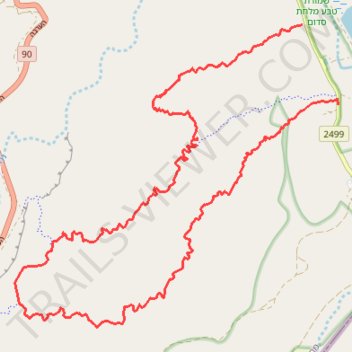
Name: Slot in the Chawar trail, distance, elevation, map, profile, GPS track
Start: 2499, Tamar Regional Council, Beersheba Subdistrict, South District, Israel (30.96918 35.35676)
End: 2499, Tamar Regional Council, Beersheba Subdistrict, South District, Israel (30.95598 35.36366)
Coordinates: 30.91956 35.30145 30.96918 35.36366
Thank you for supporting this site ❤️
Make a donation
Make a donation
Gear up for your next adventure:
As an Amazon Associate, this site earns from qualifying purchases at no extra cost to you.