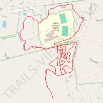
Playground Trails MTB
- Distance: 4.2 mi
- Elevation gain: 400 ft
- Maximum elevation: 430 ft
- Elevation loss: 400 ft
- Minimum elevation: 305 ft
- Moving time: 42 m 16 s
- Moving speed: 6.0 mph
- Maximum speed: 14.5 mph
- Total time: 43 m 45 s
- Global speed: 5.8 mph
Interactive trail map
Trail profile
- Distance: 4.2 mi
- Elevation gain: 400 ft
- Maximum elevation: 430 ft
- Elevation loss: 400 ft
- Minimum elevation: 305 ft
- Moving time: 42 m 16 s
- Moving speed: 6.0 mph
- Maximum speed: 14.5 mph
- Total time: 43 m 45 s
- Global speed: 5.8 mph
About this trail
Name: Playground Trails MTB trail, distance, elevation, map, profile, GPS track
Coordinates: 41.51400 -72.44889 41.52317 -72.44077
Topography: Lower Connecticut River Valley Planning Region topographic map, elevation, terrain