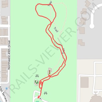
Thank you for supporting this site ❤️
Make a donation
Make a donation
Gear up for your next adventure:
As an Amazon Associate, this site earns from qualifying purchases at no extra cost to you.
Cofrin Nature Park
- Distance: 0.7 mi
- Elevation gain: 36 ft
- Maximum elevation: 144 ft
- Elevation loss: 39 ft
- Minimum elevation: 105 ft
- Moving time: 18 m 2 s
- Moving speed: 2.2 mph
- Maximum speed: 3.3 mph
- Total time: 22 m 14 s
- Global speed: 1.8 mph
Interactive trail map
Thank you for supporting this site ❤️
Make a donation
Make a donation
Gear up for your next adventure:
As an Amazon Associate, this site earns from qualifying purchases at no extra cost to you.
Trail profile
- Distance: 0.7 mi
- Elevation gain: 36 ft
- Maximum elevation: 144 ft
- Elevation loss: 39 ft
- Minimum elevation: 105 ft
- Moving time: 18 m 2 s
- Moving speed: 2.2 mph
- Maximum speed: 3.3 mph
- Total time: 22 m 14 s
- Global speed: 1.8 mph
Thank you for supporting this site ❤️
Make a donation
Make a donation
Gear up for your next adventure:
As an Amazon Associate, this site earns from qualifying purchases at no extra cost to you.
About this trail
Name: Cofrin Nature Park trail, distance, elevation, map, profile, GPS track
Coordinates: 29.66012 -82.39503 29.66344 -82.39379
Topography: Gainesville topographic map, elevation, terrain
Thank you for supporting this site ❤️
Make a donation
Make a donation
Gear up for your next adventure:
As an Amazon Associate, this site earns from qualifying purchases at no extra cost to you.