Munro hillwalk: Ghluasaid, Conbhairean, AChraileag, Fraoch-Choire
- Distance: 17.8 mi
- Elevation gain: 6,923 ft
- Maximum elevation: 3,638 ft
- Elevation loss: 6,237 ft
- Minimum elevation: 719 ft
- Moving time: 10 h 56 m
- Moving speed: 1.6 mph
- Maximum speed: 4.3 mph
- Total time: 13 h 4 m
- Global speed: 1.4 mph
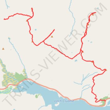
Interactive trail map
Trail profile
- Distance: 17.8 mi
- Elevation gain: 6,923 ft
- Maximum elevation: 3,638 ft
- Elevation loss: 6,237 ft
- Minimum elevation: 719 ft
- Moving time: 10 h 56 m
- Moving speed: 1.6 mph
- Maximum speed: 4.3 mph
- Total time: 13 h 4 m
- Global speed: 1.4 mph
About this trail
Name: Munro hillwalk: Ghluasaid, Conbhairean, AChraileag, Fraoch-Choire trail, distance, elevation, map, profile, GPS track
Start: A87, Highland, Scotland, United Kingdom (57.14606 -5.06832)
End: Bealach Allt a' Chaorainn Mhoir, Highland, Scotland, IV63 7YW, United Kingdom (57.19795 -5.18827)
Coordinates: 57.14513 -5.18839 57.20542 -5.06792
Other hiking, mountain biking, running and outdoor activity trails
Click on a trail to view its statistics, map and profile.
Great Glen Way (Fort William to Fort Augustus)
United Kingdom > Scotland > Highland > Fort William
Distance: 32.7 mi • Elevation gain: 1,962 ft • Maximum elevation: 354 ft
Loch Ness
United Kingdom > Scotland > Highland > Lochcarron
Distance: 66.3 mi • Elevation gain: 5,197 ft • Maximum elevation: 919 ft