Make a donation
Gear up for your next adventure:
As an Amazon Associate, this site earns from qualifying purchases at no extra cost to you.
Creek Side Trail White Blaze Loop
Cushetunk Exploration
- Distance: 6.0 mi
- Elevation gain: 456 ft
- Maximum elevation: 371 ft
- Elevation loss: 394 ft
- Minimum elevation: 187 ft
- Moving time: 50 m 33 s
- Moving speed: 7.2 mph
- Maximum speed: 35.9 mph
- Total time: 1 h 6 m
- Global speed: 5.5 mph
Interactive trail map
Make a donation
Gear up for your next adventure:
As an Amazon Associate, this site earns from qualifying purchases at no extra cost to you.
Trail profile
- Distance: 6.0 mi
- Elevation gain: 456 ft
- Maximum elevation: 371 ft
- Elevation loss: 394 ft
- Minimum elevation: 187 ft
- Moving time: 50 m 33 s
- Moving speed: 7.2 mph
- Maximum speed: 35.9 mph
- Total time: 1 h 6 m
- Global speed: 5.5 mph
Make a donation
Gear up for your next adventure:
As an Amazon Associate, this site earns from qualifying purchases at no extra cost to you.
About this trail
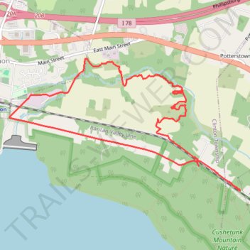
Name: Creek Side Trail White Blaze Loop trail, distance, elevation, map, profile, GPS track
Coordinates: 40.62633 -74.83379 40.64199 -74.79776
Topography: Hunterdon County topographic map, elevation, terrain
Make a donation
Gear up for your next adventure:
As an Amazon Associate, this site earns from qualifying purchases at no extra cost to you.
Other hiking, mountain biking, running and outdoor activity trails
Click on a trail to view its statistics, map and profile.
Round Valley Reservoir
United States > New Jersey > Hunterdon County > Clinton Township
Distance: 20.4 mi • Elevation gain: 3,294 ft • Maximum elevation: 840 ft