Thank you for supporting this site ❤️
Make a donation
Make a donation
Gear up for your next adventure:
As an Amazon Associate, this site earns from qualifying purchases at no extra cost to you.
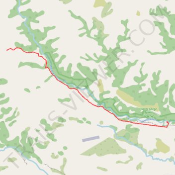
Waihi Gorge Walk
- Distance: 7.1 mi
- Elevation gain: 942 ft
- Maximum elevation: 1,670 ft
- Elevation loss: 938 ft
- Minimum elevation: 981 ft
Interactive trail map
Thank you for supporting this site ❤️
Make a donation
Make a donation
Gear up for your next adventure:
As an Amazon Associate, this site earns from qualifying purchases at no extra cost to you.
Trail profile
- Distance: 7.1 mi
- Elevation gain: 942 ft
- Maximum elevation: 1,670 ft
- Elevation loss: 938 ft
- Minimum elevation: 981 ft
Thank you for supporting this site ❤️
Make a donation
Make a donation
Gear up for your next adventure:
As an Amazon Associate, this site earns from qualifying purchases at no extra cost to you.
About this trail
Name: Waihi Gorge Walk trail, distance, elevation, map, profile, GPS track
Start: Timaru District, New Zealand (-44.00225 171.15557)
End: Timaru District, New Zealand (-44.00259 171.15545)
Coordinates: -44.00381 171.10014 -43.98404 171.15606
Thank you for supporting this site ❤️
Make a donation
Make a donation
Gear up for your next adventure:
As an Amazon Associate, this site earns from qualifying purchases at no extra cost to you.
Other hiking, mountain biking, running and outdoor activity trails
Click on a trail to view its statistics, map and profile.