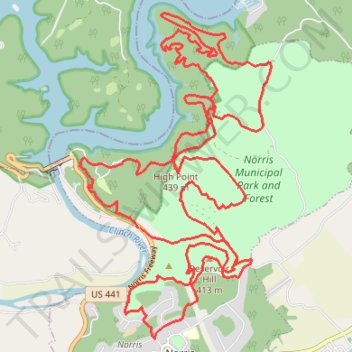
Norris Area Trail System (NATS) Poker Run Long Route Mountain Biking
- Distance: 22.6 mi
- Elevation gain: 3,514 ft
- Maximum elevation: 1,467 ft
- Elevation loss: 3,497 ft
- Minimum elevation: 850 ft
- Moving time: 3 h 36 m
- Moving speed: 6.3 mph
- Maximum speed: 27.8 mph
- Total time: 4 h 47 m
- Global speed: 4.7 mph
Interactive trail map
Trail profile
- Distance: 22.6 mi
- Elevation gain: 3,514 ft
- Maximum elevation: 1,467 ft
- Elevation loss: 3,497 ft
- Minimum elevation: 850 ft
- Moving time: 3 h 36 m
- Moving speed: 6.3 mph
- Maximum speed: 27.8 mph
- Total time: 4 h 47 m
- Global speed: 4.7 mph
About this trail
Name: Norris Area Trail System (NATS) Poker Run Long Route Mountain Biking trail, distance, elevation, map, profile, GPS track
Coordinates: 36.19787 -84.08693 36.24781 -84.05056
Topography: Anderson County topographic map, elevation, terrain