Thank you for supporting this site ❤️
Make a donation
Make a donation
Gear up for your next adventure:
As an Amazon Associate, this site earns from qualifying purchases at no extra cost to you.
Gravel Loop from Gisborne
- Distance: 39.2 mi
- Elevation gain: 4,406 ft
- Maximum elevation: 1,447 ft
- Elevation loss: 4,409 ft
- Minimum elevation: 3 ft
- Moving time: 3 h 12 m
- Moving speed: 12.2 mph
- Maximum speed: 34.7 mph
- Total time: 3 h 26 m
- Global speed: 11.4 mph
Interactive trail map
Thank you for supporting this site ❤️
Make a donation
Make a donation
Gear up for your next adventure:
As an Amazon Associate, this site earns from qualifying purchases at no extra cost to you.
Trail profile
- Distance: 39.2 mi
- Elevation gain: 4,406 ft
- Maximum elevation: 1,447 ft
- Elevation loss: 4,409 ft
- Minimum elevation: 3 ft
- Moving time: 3 h 12 m
- Moving speed: 12.2 mph
- Maximum speed: 34.7 mph
- Total time: 3 h 26 m
- Global speed: 11.4 mph
Thank you for supporting this site ❤️
Make a donation
Make a donation
Gear up for your next adventure:
As an Amazon Associate, this site earns from qualifying purchases at no extra cost to you.
About this trail
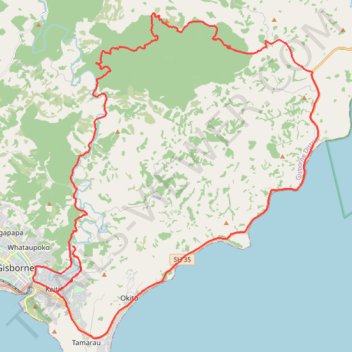
Name: Gravel Loop from Gisborne trail, distance, elevation, map, profile, GPS track
Start: 184, Darwin Road, Gisborne District, Gisborne, 4020, New Zealand (-38.65323 178.05289)
End: 186, Darwin Road, Gisborne District, Gisborne, 4020, New Zealand (-38.65237 178.05147)
Coordinates: -38.69117 178.03037 -38.55446 178.18395
Thank you for supporting this site ❤️
Make a donation
Make a donation
Gear up for your next adventure:
As an Amazon Associate, this site earns from qualifying purchases at no extra cost to you.