Thank you for supporting this site ❤️
Make a donation
Make a donation
Gear up for your next adventure:
As an Amazon Associate, this site earns from qualifying purchases at no extra cost to you.
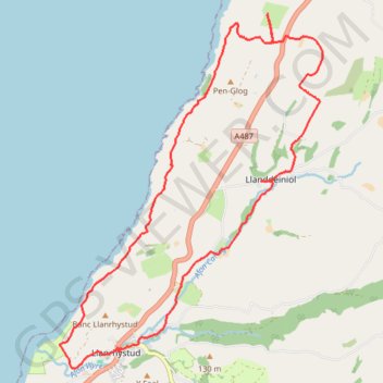
Llanrhystud Llanddeiniol loop walk
- Distance: 10.1 mi
- Elevation gain: 1,394 ft
- Maximum elevation: 554 ft
- Elevation loss: 1,398 ft
- Minimum elevation: 20 ft
- Moving time: 4 h 34 m
- Moving speed: 2.2 mph
- Maximum speed: 3.4 mph
- Total time: 7 h 20 m
- Global speed: 1.4 mph
Interactive trail map
Thank you for supporting this site ❤️
Make a donation
Make a donation
Gear up for your next adventure:
As an Amazon Associate, this site earns from qualifying purchases at no extra cost to you.
Trail profile
- Distance: 10.1 mi
- Elevation gain: 1,394 ft
- Maximum elevation: 554 ft
- Elevation loss: 1,398 ft
- Minimum elevation: 20 ft
- Moving time: 4 h 34 m
- Moving speed: 2.2 mph
- Maximum speed: 3.4 mph
- Total time: 7 h 20 m
- Global speed: 1.4 mph
Thank you for supporting this site ❤️
Make a donation
Make a donation
Gear up for your next adventure:
As an Amazon Associate, this site earns from qualifying purchases at no extra cost to you.
About this trail
Name: Llanrhystud Llanddeiniol loop walk trail, distance, elevation, map, profile, GPS track
Coordinates: 52.30351 -4.15697 52.34980 -4.10085
Thank you for supporting this site ❤️
Make a donation
Make a donation
Gear up for your next adventure:
As an Amazon Associate, this site earns from qualifying purchases at no extra cost to you.