Thank you for supporting this site ❤️
Make a donation
Make a donation
Gear up for your next adventure:
As an Amazon Associate, this site earns from qualifying purchases at no extra cost to you.
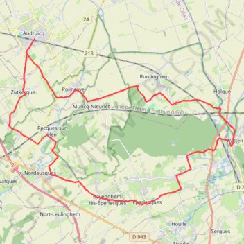
Les 3 Cayelles - Audruicq
- Distance: 22.8 mi
- Elevation gain: 633 ft
- Maximum elevation: 184 ft
- Elevation loss: 633 ft
- Minimum elevation: 7 ft
Interactive trail map
Thank you for supporting this site ❤️
Make a donation
Make a donation
Gear up for your next adventure:
As an Amazon Associate, this site earns from qualifying purchases at no extra cost to you.
Trail profile
- Distance: 22.8 mi
- Elevation gain: 633 ft
- Maximum elevation: 184 ft
- Elevation loss: 633 ft
- Minimum elevation: 7 ft
Thank you for supporting this site ❤️
Make a donation
Make a donation
Gear up for your next adventure:
As an Amazon Associate, this site earns from qualifying purchases at no extra cost to you.
About this trail
Name: Les 3 Cayelles - Audruicq trail, distance, elevation, map, profile, GPS track
Coordinates: 50.80465 2.05855 50.87600 2.21232
Thank you for supporting this site ❤️
Make a donation
Make a donation
Gear up for your next adventure:
As an Amazon Associate, this site earns from qualifying purchases at no extra cost to you.