Make a donation
Gear up for your next adventure:
As an Amazon Associate, this site earns from qualifying purchases at no extra cost to you.
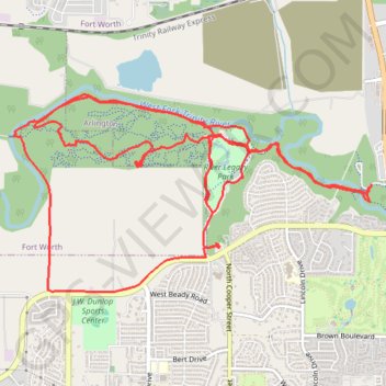
River Legacy Park MTB Loop
Mountain bike loop in River Legacy Park via West Fork Trinity River. #MTB #Loop #Forest #River #Nature
- Distance: 11.9 mi
- Elevation gain: 164 ft
- Maximum elevation: 495 ft
- Elevation loss: 164 ft
- Minimum elevation: 463 ft
- Moving time: 1 h 17 m
- Moving speed: 9.2 mph
- Maximum speed: 33.3 mph
- Total time: 1 h 18 m
- Global speed: 9.0 mph
Interactive trail map
Make a donation
Gear up for your next adventure:
As an Amazon Associate, this site earns from qualifying purchases at no extra cost to you.
Trail profile
- Distance: 11.9 mi
- Elevation gain: 164 ft
- Maximum elevation: 495 ft
- Elevation loss: 164 ft
- Minimum elevation: 463 ft
- Moving time: 1 h 17 m
- Moving speed: 9.2 mph
- Maximum speed: 33.3 mph
- Total time: 1 h 18 m
- Global speed: 9.0 mph
Make a donation
Gear up for your next adventure:
As an Amazon Associate, this site earns from qualifying purchases at no extra cost to you.
About this trail
Name: River Legacy Park MTB Loop trail, distance, elevation, map, profile, GPS track
Start: Winter Rose Way, Arlington, Tarrant County, Texas, 76006, United States (32.78899 -97.09901)
End: Winter Rose Way, Arlington, Tarrant County, Texas, 76006, United States (32.78892 -97.09902)
Coordinates: 32.77934 -97.13722 32.79711 -97.09901
Topography: Arlington topographic map, elevation, terrain
Make a donation
Gear up for your next adventure:
As an Amazon Associate, this site earns from qualifying purchases at no extra cost to you.