Make a donation
Gear up for your next adventure:
As an Amazon Associate, this site earns from qualifying purchases at no extra cost to you.
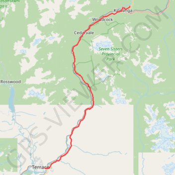
Terrace - Kitwanga
Skeena River. #Bike
- Distance: 60.0 mi
- Elevation gain: 3,264 ft
- Maximum elevation: 758 ft
- Elevation loss: 2,759 ft
- Minimum elevation: 180 ft
Interactive trail map
Make a donation
Gear up for your next adventure:
As an Amazon Associate, this site earns from qualifying purchases at no extra cost to you.
Trail profile
- Distance: 60.0 mi
- Elevation gain: 3,264 ft
- Maximum elevation: 758 ft
- Elevation loss: 2,759 ft
- Minimum elevation: 180 ft
Make a donation
Gear up for your next adventure:
As an Amazon Associate, this site earns from qualifying purchases at no extra cost to you.
About this trail
Name: Terrace - Kitwanga trail, distance, elevation, map, profile, GPS track
Coordinates: 54.51110 -128.57119 55.11317 -128.02217
Make a donation
Gear up for your next adventure:
As an Amazon Associate, this site earns from qualifying purchases at no extra cost to you.
Other hiking, mountain biking, running and outdoor activity trails
Click on a trail to view its statistics, map and profile.
Trace of Trail around Ferry island as well as pedestrian access via the highway bridge and roundabout to the west
Canada > British Columbia > Regional District of Kitimat-Stikine > Area E (Thornhill) > Thornhill
Kitimat-Stikine - Easy Run
Distance: 4.7 mi • Elevation gain: 463 ft • Maximum elevation: 276 ft