Thank you for supporting this site ❤️
Make a donation
Make a donation
Gear up for your next adventure:
As an Amazon Associate, this site earns from qualifying purchases at no extra cost to you.
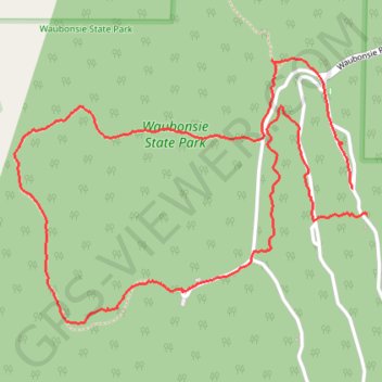
Waubonsie State Park
- Distance: 3.4 mi
- Elevation gain: 387 ft
- Maximum elevation: 1,243 ft
- Elevation loss: 400 ft
- Minimum elevation: 1,056 ft
- Moving time: 1 h 33 m
- Moving speed: 2.2 mph
- Maximum speed: 7.4 mph
- Total time: 2 h 15 m
- Global speed: 1.5 mph
Interactive trail map
Thank you for supporting this site ❤️
Make a donation
Make a donation
Gear up for your next adventure:
As an Amazon Associate, this site earns from qualifying purchases at no extra cost to you.
Trail profile
- Distance: 3.4 mi
- Elevation gain: 387 ft
- Maximum elevation: 1,243 ft
- Elevation loss: 400 ft
- Minimum elevation: 1,056 ft
- Moving time: 1 h 33 m
- Moving speed: 2.2 mph
- Maximum speed: 7.4 mph
- Total time: 2 h 15 m
- Global speed: 1.5 mph
Thank you for supporting this site ❤️
Make a donation
Make a donation
Gear up for your next adventure:
As an Amazon Associate, this site earns from qualifying purchases at no extra cost to you.
About this trail
Name: Waubonsie State Park trail, distance, elevation, map, profile, GPS track
Start: Fremont County, Iowa, United States (40.67086 -95.68710)
End: Fremont County, Iowa, United States (40.66993 -95.68640)
Coordinates: 40.66603 -95.70315 40.67555 -95.68640
Topography: Fremont County topographic map, elevation, terrain
Thank you for supporting this site ❤️
Make a donation
Make a donation
Gear up for your next adventure:
As an Amazon Associate, this site earns from qualifying purchases at no extra cost to you.