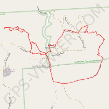
Scott Creek mine hunting, further exploration
- Distance: 2.5 mi
- Elevation gain: 525 ft
- Maximum elevation: 1,063 ft
- Elevation loss: 525 ft
- Minimum elevation: 768 ft
- Moving time: 1 h 9 m
- Moving speed: 2.2 mph
- Maximum speed: 5.2 mph
- Total time: 1 h 41 m
- Global speed: 1.5 mph
Interactive trail map
Trail profile
- Distance: 2.5 mi
- Elevation gain: 525 ft
- Maximum elevation: 1,063 ft
- Elevation loss: 525 ft
- Minimum elevation: 768 ft
- Moving time: 1 h 9 m
- Moving speed: 2.2 mph
- Maximum speed: 5.2 mph
- Total time: 1 h 41 m
- Global speed: 1.5 mph
About this trail
Name: Scott Creek mine hunting, further exploration trail, distance, elevation, map, profile, GPS track
Coordinates: -35.08687 138.66981 -35.08151 138.68118
Other hiking, mountain biking, running and outdoor activity trails
Click on a trail to view its statistics, map and profile.
The long lost mines of Scott Creek
Australia > South Australia > City of Onkaparinga > Adelaide > Clarendon > Cherry Gardens
Bush walk
Distance: 2.8 mi • Elevation gain: 636 ft • Maximum elevation: 1,158 ft
Bush explore of Scott Creek
Australia > South Australia > City of Onkaparinga > Adelaide > Cherry Gardens
Lunch Walk
Distance: 2.4 mi • Elevation gain: 489 ft • Maximum elevation: 1,014 ft