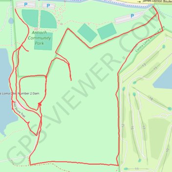
Contra Loma Regional Park loop
Recorded while walking the Old Ranch Loop Trail and nearby trails in Antioch, California.
- Distance: 3.9 mi
- Elevation gain: 276 ft
- Maximum elevation: 230 ft
- Elevation loss: 308 ft
- Minimum elevation: 121 ft
- Moving time: 1 h 14 m
- Moving speed: 3.1 mph
- Maximum speed: 4.7 mph
- Total time: 1 h 23 m
- Global speed: 2.8 mph
Interactive trail map
Trail profile
- Distance: 3.9 mi
- Elevation gain: 276 ft
- Maximum elevation: 230 ft
- Elevation loss: 308 ft
- Minimum elevation: 121 ft
- Moving time: 1 h 14 m
- Moving speed: 3.1 mph
- Maximum speed: 4.7 mph
- Total time: 1 h 23 m
- Global speed: 2.8 mph
About this trail
Name: Contra Loma Regional Park loop trail, distance, elevation, map, profile, GPS track
Coordinates: 37.97051 -121.82258 37.97951 -121.81155
Topography: Antioch topographic map, elevation, terrain