Make a donation
Gear up for your next adventure:
As an Amazon Associate, this site earns from qualifying purchases at no extra cost to you.
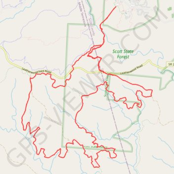
Scott State Forest
Scott County
- Distance: 17.4 mi
- Elevation gain: 1,273 ft
- Maximum elevation: 1,591 ft
- Elevation loss: 1,270 ft
- Minimum elevation: 1,391 ft
Interactive trail map
Make a donation
Gear up for your next adventure:
As an Amazon Associate, this site earns from qualifying purchases at no extra cost to you.
Trail profile
- Distance: 17.4 mi
- Elevation gain: 1,273 ft
- Maximum elevation: 1,591 ft
- Elevation loss: 1,270 ft
- Minimum elevation: 1,391 ft
Make a donation
Gear up for your next adventure:
As an Amazon Associate, this site earns from qualifying purchases at no extra cost to you.
About this trail
Name: Scott State Forest trail, distance, elevation, map, profile, GPS track
Coordinates: 36.45168 -84.72896 36.48866 -84.69168
Topography: Scott County topographic map, elevation, terrain
Make a donation
Gear up for your next adventure:
As an Amazon Associate, this site earns from qualifying purchases at no extra cost to you.
Other hiking, mountain biking, running and outdoor activity trails
Click on a trail to view its statistics, map and profile.
Cumberland Valley Loop Trail
United States > Tennessee > Fentress County
Fentress County Dia
Distance: 18.2 mi • Elevation gain: 1,683 ft • Maximum elevation: 1,591 ft