Hunter Mountain Fire Tower and Overlook
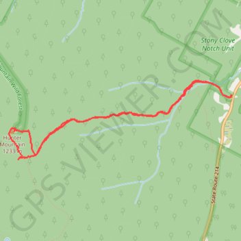
Interactive trail map
Trail profile
- Distance: 4.9 mi
- Elevation gain: 2,205 ft
- Maximum elevation: 4,019 ft
- Elevation loss: 2,208 ft
- Minimum elevation: 1,834 ft
About this trail
Name: Hunter Mountain Fire Tower and Overlook trail, distance, elevation, map, profile, GPS track
Coordinates: 42.17463 -74.23090 42.18361 -74.19686
Topography: Greene County topographic map, elevation, terrain
Other hiking, mountain biking, running and outdoor activity trails
Click on a trail to view its statistics, map and profile.
Hunter Mountain Loop
United States > New York > Greene County > Town of Hunter > Edgewood
Loop hike to Hunter Mountain via Lane Road, Becker Hollow Trail, Yellow Connector Trail, Hunter Mountain Fire Tower, Hunter Mountain Trail, Yellow Side Trail and Hunter Mountain Overlook in the Hunter-West Kill Wilderness and the Catskill Park. #Hiking #Loop #Mountain #Nature #Forest #Park
Distance: 4.8 mi • Elevation gain: 2,257 ft • Maximum elevation: 4,019 ft