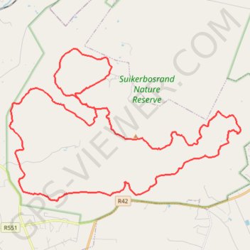
Suikerbosrand Nature Reserve
- Distance: 35.6 mi
- Elevation gain: 4,163 ft
- Maximum elevation: 6,237 ft
- Elevation loss: 4,170 ft
- Minimum elevation: 5,115 ft
Interactive trail map
Trail profile
- Distance: 35.6 mi
- Elevation gain: 4,163 ft
- Maximum elevation: 6,237 ft
- Elevation loss: 4,170 ft
- Minimum elevation: 5,115 ft
About this trail
Name: Suikerbosrand Nature Reserve trail, distance, elevation, map, profile, GPS track
Coordinates: -26.54639 28.15451 -26.46530 28.29194