Thank you for supporting this site ❤️
Make a donation
Make a donation
Gear up for your next adventure:
As an Amazon Associate, this site earns from qualifying purchases at no extra cost to you.
Attadale - Woodman Point
Interactive trail map
Thank you for supporting this site ❤️
Make a donation
Make a donation
Gear up for your next adventure:
As an Amazon Associate, this site earns from qualifying purchases at no extra cost to you.
Trail profile
- Distance: 24.8 mi
- Elevation gain: 902 ft
- Maximum elevation: 72 ft
- Elevation loss: 951 ft
- Minimum elevation: -3 ft
Thank you for supporting this site ❤️
Make a donation
Make a donation
Gear up for your next adventure:
As an Amazon Associate, this site earns from qualifying purchases at no extra cost to you.
About this trail
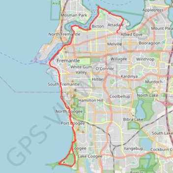
Name: Attadale - Woodman Point trail, distance, elevation, map, profile, GPS track
Start: Redcourt Road, Attadale, City of Melville, Western Australia, 6156, Australia (-32.03172 115.80416)
Coordinates: -32.13641 115.74141 -32.01130 115.80957
Thank you for supporting this site ❤️
Make a donation
Make a donation
Gear up for your next adventure:
As an Amazon Associate, this site earns from qualifying purchases at no extra cost to you.
Other hiking, mountain biking, running and outdoor activity trails
Click on a trail to view its statistics, map and profile.
MAnning Park
Distance: 7.4 mi • Elevation gain: 594 ft • Maximum elevation: 151 ft