Make a donation
Gear up for your next adventure:
As an Amazon Associate, this site earns from qualifying purchases at no extra cost to you.
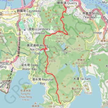
Wilson Trail
- Distance: 8.1 mi
- Elevation gain: 3,386 ft
- Maximum elevation: 1,345 ft
- Elevation loss: 3,189 ft
- Minimum elevation: 85 ft
Interactive trail map
Make a donation
Gear up for your next adventure:
As an Amazon Associate, this site earns from qualifying purchases at no extra cost to you.
Trail profile
- Distance: 8.1 mi
- Elevation gain: 3,386 ft
- Maximum elevation: 1,345 ft
- Elevation loss: 3,189 ft
- Minimum elevation: 85 ft
Make a donation
Gear up for your next adventure:
As an Amazon Associate, this site earns from qualifying purchases at no extra cost to you.
About this trail
Name: Wilson Trail trail, distance, elevation, map, profile, GPS track
Coordinates: 22.22368 114.19483 22.28604 114.21338
Make a donation
Gear up for your next adventure:
As an Amazon Associate, this site earns from qualifying purchases at no extra cost to you.
Other hiking, mountain biking, running and outdoor activity trails
Click on a trail to view its statistics, map and profile.
渣甸北坑 渣甸東石河
China > Hong Kong > Hong Kong Island
Loop hike
Distance: 2.6 mi • Elevation gain: 1,158 ft • Maximum elevation: 1,345 ft
Wilson Trail Full Route
China > Hong Kong > Hong Kong Island
Distance: 50.5 mi • Elevation gain: 14,534 ft • Maximum elevation: 2,011 ft
Hong Kong island ride
China > Hong Kong > Hong Kong Island
#Bike
Distance: 38.4 mi • Elevation gain: 7,060 ft • Maximum elevation: 1,657 ft
Jardine's Lookout
China > Hong Kong > Hong Kong Island
Distance: 3.8 mi • Elevation gain: 1,148 ft • Maximum elevation: 1,345 ft
Make a donation
Gear up for your next adventure:
As an Amazon Associate, this site earns from qualifying purchases at no extra cost to you.
Trail Planner Map
China > Hong Kong > Hong Kong Island
Distance: 12.6 mi • Elevation gain: 3,776 ft • Maximum elevation: 1,388 ft
雙潭渣大
China > Hong Kong > Hong Kong Island
Distance: 4.2 mi • Elevation gain: 1,158 ft • Maximum elevation: 1,001 ft
畢鰂 紫潭北坑
China > Hong Kong > Hong Kong Island
Eastern District Hike
Distance: 5.5 mi • Elevation gain: 1,926 ft • Maximum elevation: 1,339 ft