Make a donation
Gear up for your next adventure:
As an Amazon Associate, this site earns from qualifying purchases at no extra cost to you.
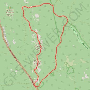
Sullivan Rock - Mount Vincent - Mount Cuthbert
Interactive trail map
Make a donation
Gear up for your next adventure:
As an Amazon Associate, this site earns from qualifying purchases at no extra cost to you.
Trail profile
- Distance: 10.8 mi
- Elevation gain: 1,398 ft
- Maximum elevation: 1,654 ft
- Elevation loss: 1,398 ft
- Minimum elevation: 866 ft
Make a donation
Gear up for your next adventure:
As an Amazon Associate, this site earns from qualifying purchases at no extra cost to you.
About this trail
Name: Sullivan Rock - Mount Vincent - Mount Cuthbert trail, distance, elevation, map, profile, GPS track
Start: Albany Highway, Mount Cooke, Shire Of Wandering, Western Australia, Australia (-32.37964 116.25082)
End: Albany Highway, Mount Cooke, Shire Of Wandering, Western Australia, Australia (-32.38011 116.25044)
Coordinates: -32.38119 116.24166 -32.32651 116.27722
Make a donation
Gear up for your next adventure:
As an Amazon Associate, this site earns from qualifying purchases at no extra cost to you.
Other hiking, mountain biking, running and outdoor activity trails
Click on a trail to view its statistics, map and profile.
Three Mountains Circuit: Mount Vincent - Mount Cuthbert - Mount Randall
Australia > Western Australia > Jarrahdale
Bibbulmun Track. Monadnocks Conservation Park. #Hiking #Loop #Monadnocks
Distance: 9.1 mi • Elevation gain: 1,385 ft • Maximum elevation: 1,657 ft
Sullivan Rock - Mount Cooke
Australia > Western Australia > Jarrahdale
Distance: 6.0 mi • Elevation gain: 1,204 ft • Maximum elevation: 1,847 ft