Thank you for supporting this site ❤️
Make a donation
Make a donation
Gear up for your next adventure:
As an Amazon Associate, this site earns from qualifying purchases at no extra cost to you.
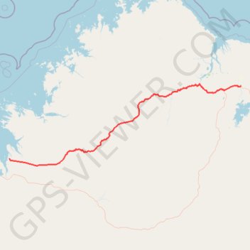
Gibb River Road: Kununurra - Derby
#Bike
- Distance: 438.3 mi
- Elevation gain: 10,358 ft
- Maximum elevation: 1,798 ft
- Elevation loss: 10,476 ft
- Minimum elevation: 13 ft
Interactive trail map
Thank you for supporting this site ❤️
Make a donation
Make a donation
Gear up for your next adventure:
As an Amazon Associate, this site earns from qualifying purchases at no extra cost to you.
Trail profile
- Distance: 438.3 mi
- Elevation gain: 10,358 ft
- Maximum elevation: 1,798 ft
- Elevation loss: 10,476 ft
- Minimum elevation: 13 ft
Thank you for supporting this site ❤️
Make a donation
Make a donation
Gear up for your next adventure:
As an Amazon Associate, this site earns from qualifying purchases at no extra cost to you.
About this trail
Name: Gibb River Road: Kununurra - Derby trail, distance, elevation, map, profile, GPS track
Start: Kununurra, Shire Of Wyndham-East Kimberley, Western Australia, 6743, Australia (-15.77843 128.74385)
Coordinates: -17.46121 123.64771 -15.73724 128.74385
Thank you for supporting this site ❤️
Make a donation
Make a donation
Gear up for your next adventure:
As an Amazon Associate, this site earns from qualifying purchases at no extra cost to you.