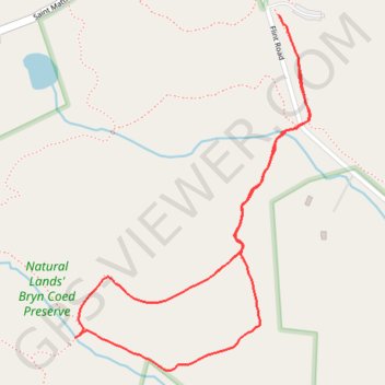
Natural Lands' Brin Coed Reserve
Loop hike through Natural Lands' Brin Coed Reserve. #Hiking #Loop #Countryside #Nature #Forest
- Distance: 1.4 mi
- Elevation gain: 75 ft
- Maximum elevation: 377 ft
- Elevation loss: 92 ft
- Minimum elevation: 312 ft
- Moving time: 28 m 6 s
- Moving speed: 3.0 mph
- Maximum speed: 3.8 mph
- Total time: 28 m 6 s
- Global speed: 3.0 mph
Interactive trail map
Trail profile
- Distance: 1.4 mi
- Elevation gain: 75 ft
- Maximum elevation: 377 ft
- Elevation loss: 92 ft
- Minimum elevation: 312 ft
- Moving time: 28 m 6 s
- Moving speed: 3.0 mph
- Maximum speed: 3.8 mph
- Total time: 28 m 6 s
- Global speed: 3.0 mph
About this trail
Name: Natural Lands' Brin Coed Reserve trail, distance, elevation, map, profile, GPS track
Coordinates: 40.12227 -75.61375 40.12925 -75.60773
Topography: West Vincent Township topographic map, elevation, terrain