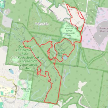
Daisy Hill / Koala Bushland / Neville Lawrie Loop
Loop hike / run through Daisy Hill Conservation Park, Koala Bushland Coordinated Conservation Area and Neville Lawrie Reserve. #Hiking #Running #Loop #Nature #Forest #River #Lake #Park
- Distance: 13.7 mi
- Elevation gain: 1,345 ft
- Maximum elevation: 394 ft
- Elevation loss: 1,345 ft
- Minimum elevation: 121 ft
- Moving time: 2 h 52 m
- Moving speed: 4.8 mph
- Maximum speed: 12.5 mph
- Total time: 2 h 54 m
- Global speed: 4.7 mph
Interactive trail map
Trail profile
- Distance: 13.7 mi
- Elevation gain: 1,345 ft
- Maximum elevation: 394 ft
- Elevation loss: 1,345 ft
- Minimum elevation: 121 ft
- Moving time: 2 h 52 m
- Moving speed: 4.8 mph
- Maximum speed: 12.5 mph
- Total time: 2 h 54 m
- Global speed: 4.7 mph
About this trail
Name: Daisy Hill / Koala Bushland / Neville Lawrie Loop trail, distance, elevation, map, profile, GPS track
Coordinates: -27.63838 153.15833 -27.60033 153.18507
Other hiking, mountain biking, running and outdoor activity trails
Click on a trail to view its statistics, map and profile.
Eastern Escarpment Conservation Area, Venman Bushland National Park, Daisy Hill Conservation Park, Koala Bushland Conservation Area and Neville Lawrie Reserve loop
Australia > Queensland > Brisbane
Distance: 16.3 mi • Elevation gain: 1,965 ft • Maximum elevation: 715 ft
Venman and Daisy parks
Distance: 11.9 mi • Elevation gain: 1,234 ft • Maximum elevation: 456 ft
Venman and Daisy Loop
Distance: 11.3 mi • Elevation gain: 820 ft • Maximum elevation: 456 ft
Daisy Hill Loop
Distance: 10.4 mi • Elevation gain: 951 ft • Maximum elevation: 390 ft