Thank you for supporting this site ❤️
Make a donation
Make a donation
Gear up for your next adventure:
As an Amazon Associate, this site earns from qualifying purchases at no extra cost to you.
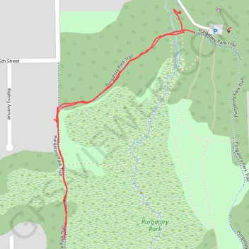
Purgatory Park Trail
- Distance: 0.9 mi
- Elevation gain: 46 ft
- Maximum elevation: 909 ft
- Elevation loss: 46 ft
- Minimum elevation: 879 ft
- Moving time: 17 m 33 s
- Moving speed: 3.0 mph
- Maximum speed: 4.8 mph
- Total time: 18 m 37 s
- Global speed: 2.8 mph
Interactive trail map
Thank you for supporting this site ❤️
Make a donation
Make a donation
Gear up for your next adventure:
As an Amazon Associate, this site earns from qualifying purchases at no extra cost to you.
Trail profile
- Distance: 0.9 mi
- Elevation gain: 46 ft
- Maximum elevation: 909 ft
- Elevation loss: 46 ft
- Minimum elevation: 879 ft
- Moving time: 17 m 33 s
- Moving speed: 3.0 mph
- Maximum speed: 4.8 mph
- Total time: 18 m 37 s
- Global speed: 2.8 mph
Thank you for supporting this site ❤️
Make a donation
Make a donation
Gear up for your next adventure:
As an Amazon Associate, this site earns from qualifying purchases at no extra cost to you.
About this trail
Name: Purgatory Park Trail trail, distance, elevation, map, profile, GPS track
Coordinates: 44.90108 -93.50335 44.90538 -93.49964
Topography: Hennepin County topographic map, elevation, terrain
Thank you for supporting this site ❤️
Make a donation
Make a donation
Gear up for your next adventure:
As an Amazon Associate, this site earns from qualifying purchases at no extra cost to you.
Other hiking, mountain biking, running and outdoor activity trails
Click on a trail to view its statistics, map and profile.
Purgatory Park Loop Trail
United States > Minnesota > Hennepin County > Minnetonka
Distance: 1.3 mi • Elevation gain: 75 ft • Maximum elevation: 922 ft