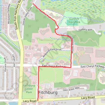
Woods Hollow Greenway
- Distance: 1.2 mi
- Elevation gain: 33 ft
- Maximum elevation: 981 ft
- Elevation loss: 79 ft
- Minimum elevation: 915 ft
- Moving time: 12 m 9 s
- Moving speed: 5.9 mph
- Maximum speed: 14.9 mph
- Total time: 13 m 21 s
- Global speed: 5.3 mph
Interactive trail map
Trail profile
- Distance: 1.2 mi
- Elevation gain: 33 ft
- Maximum elevation: 981 ft
- Elevation loss: 79 ft
- Minimum elevation: 915 ft
- Moving time: 12 m 9 s
- Moving speed: 5.9 mph
- Maximum speed: 14.9 mph
- Total time: 13 m 21 s
- Global speed: 5.3 mph
About this trail
Name: Woods Hollow Greenway trail, distance, elevation, map, profile, GPS track
Start: Lacy Road, Fitchburg, Dane County, Wisconsin, 53593, United States (43.00113 -89.42534)
Coordinates: 43.00113 -89.42608 43.01180 -89.42021
Topography: Dane County topographic map, elevation, terrain
Other hiking, mountain biking, running and outdoor activity trails
Click on a trail to view its statistics, map and profile.
Paoli via Southwest Bike Path, Badger State Trail and Military Ridge State Trail
United States > Wisconsin > Dane County > Madison
Distance: 26.9 mi • Elevation gain: 945 ft • Maximum elevation: 1,060 ft
Capital Springs Recreation Area
United States > Wisconsin > Dane County
Distance: 18.6 mi • Elevation gain: 840 ft • Maximum elevation: 1,093 ft
Belleville via Southwest Bike Path and Badger State Trail
United States > Wisconsin > Dane County > Madison
Distance: 37.8 mi • Elevation gain: 1,161 ft • Maximum elevation: 1,115 ft