Make a donation
Gear up for your next adventure:
As an Amazon Associate, this site earns from qualifying purchases at no extra cost to you.
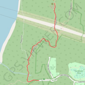
Holmes Peak
Gowlland Tod Provincial Park. #Hiking #GowllandTod
- Distance: 1.7 mi
- Elevation gain: 404 ft
- Maximum elevation: 1,027 ft
- Elevation loss: 404 ft
- Minimum elevation: 686 ft
Interactive trail map
Make a donation
Gear up for your next adventure:
As an Amazon Associate, this site earns from qualifying purchases at no extra cost to you.
Trail profile
- Distance: 1.7 mi
- Elevation gain: 404 ft
- Maximum elevation: 1,027 ft
- Elevation loss: 404 ft
- Minimum elevation: 686 ft
Make a donation
Gear up for your next adventure:
As an Amazon Associate, this site earns from qualifying purchases at no extra cost to you.
About this trail
Name: Holmes Peak trail, distance, elevation, map, profile, GPS track
Coordinates: 48.50876 -123.53406 48.51622 -123.52960
Make a donation
Gear up for your next adventure:
As an Amazon Associate, this site earns from qualifying purchases at no extra cost to you.
Other hiking, mountain biking, running and outdoor activity trails
Click on a trail to view its statistics, map and profile.
Caleb Pike - Mount Finlayson - Holmes Peak
Canada > British Columbia > Capital Regional District > Highlands
Gowlland Tod Provincial Park. #Hiking #Loop #GowllandTod
Distance: 7.1 mi • Elevation gain: 1,677 ft • Maximum elevation: 1,332 ft
Rowntree road - Jocelyn Hill
Canada > British Columbia > Capital Regional District > Highlands
Gowlland Tod Provincial Park. #Hiking #GowllandTod
Distance: 7.6 mi • Elevation gain: 1,719 ft • Maximum elevation: 1,348 ft
BBF loop to the Skydeck in Nanaimo
Canada > British Columbia > Cowichan Valley Regional District > Area A (Mill Bay / Malahat) > Mill Bay
BBF loop to the Skydeck
Distance: 201.0 mi • Elevation gain: 20,413 ft • Maximum elevation: 2,316 ft