Thank you for supporting this site ❤️
Make a donation
Make a donation
Gear up for your next adventure:
As an Amazon Associate, this site earns from qualifying purchases at no extra cost to you.
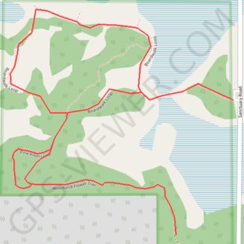
Clifford E Lee Nature Sanctuary Loop
- Distance: 2.3 mi
- Elevation gain: 69 ft
- Maximum elevation: 2,316 ft
- Elevation loss: 69 ft
- Minimum elevation: 2,293 ft
Interactive trail map
Thank you for supporting this site ❤️
Make a donation
Make a donation
Gear up for your next adventure:
As an Amazon Associate, this site earns from qualifying purchases at no extra cost to you.
Trail profile
- Distance: 2.3 mi
- Elevation gain: 69 ft
- Maximum elevation: 2,316 ft
- Elevation loss: 69 ft
- Minimum elevation: 2,293 ft
Thank you for supporting this site ❤️
Make a donation
Make a donation
Gear up for your next adventure:
As an Amazon Associate, this site earns from qualifying purchases at no extra cost to you.
About this trail
Name: Clifford E Lee Nature Sanctuary Loop trail, distance, elevation, map, profile, GPS track
Start: Boardwalk Loop, Parkland County, Alberta, T7Y 1C5, Canada (53.41308 -113.78774)
End: Boardwalk Loop, Parkland County, Alberta, T7Y 1C5, Canada (53.41308 -113.78774)
Coordinates: 53.40945 -113.79783 53.41553 -113.78774
Thank you for supporting this site ❤️
Make a donation
Make a donation
Gear up for your next adventure:
As an Amazon Associate, this site earns from qualifying purchases at no extra cost to you.