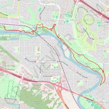
Baker Park - Bowmont Park - Dale Hodges Park
Interactive trail map
Trail profile
- Distance: 7.9 mi
- Elevation gain: 745 ft
- Maximum elevation: 3,638 ft
- Elevation loss: 745 ft
- Minimum elevation: 3,491 ft
About this trail
Name: Baker Park - Bowmont Park - Dale Hodges Park trail, distance, elevation, map, profile, GPS track
Start: Scenic Bow Road NW, Greenwood/Greenbriar, Calgary, Alberta, T3B 6G1, Canada (51.10118 -114.21928)
End: Scenic Bow Road NW, Greenwood/Greenbriar, Calgary, Alberta, T3B 6G1, Canada (51.10118 -114.21928)
Coordinates: 51.08067 -114.21928 51.10202 -114.16352