Thank you for supporting this site ❤️
Make a donation
Make a donation
Gear up for your next adventure:
As an Amazon Associate, this site earns from qualifying purchases at no extra cost to you.
Brant Park Conservation Area - Grand River
Interactive trail map
Thank you for supporting this site ❤️
Make a donation
Make a donation
Gear up for your next adventure:
As an Amazon Associate, this site earns from qualifying purchases at no extra cost to you.
Trail profile
- Distance: 9.7 mi
- Elevation gain: 253 ft
- Maximum elevation: 725 ft
- Elevation loss: 253 ft
- Minimum elevation: 659 ft
Thank you for supporting this site ❤️
Make a donation
Make a donation
Gear up for your next adventure:
As an Amazon Associate, this site earns from qualifying purchases at no extra cost to you.
About this trail
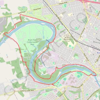
Name: Brant Park Conservation Area - Grand River trail, distance, elevation, map, profile, GPS track
Start: 290, Dufferin Avenue, Holmedale, Brantford, Ontario, N3T 5B1, Canada (43.15025 -80.29233)
End: 290, Dufferin Avenue, Holmedale, Brantford, Ontario, N3T 5B1, Canada (43.15025 -80.29233)
Coordinates: 43.13216 -80.32021 43.16145 -80.26793
Thank you for supporting this site ❤️
Make a donation
Make a donation
Gear up for your next adventure:
As an Amazon Associate, this site earns from qualifying purchases at no extra cost to you.