Thank you for supporting this site ❤️
Make a donation
Make a donation
Gear up for your next adventure:
As an Amazon Associate, this site earns from qualifying purchases at no extra cost to you.
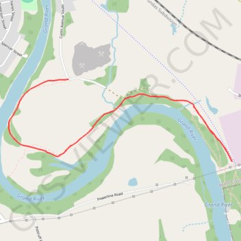
Grand Valley Trail
Grand River. #Hiking
- Distance: 3.7 mi
- Elevation gain: 220 ft
- Maximum elevation: 830 ft
- Elevation loss: 220 ft
- Minimum elevation: 712 ft
Interactive trail map
Thank you for supporting this site ❤️
Make a donation
Make a donation
Gear up for your next adventure:
As an Amazon Associate, this site earns from qualifying purchases at no extra cost to you.
Trail profile
- Distance: 3.7 mi
- Elevation gain: 220 ft
- Maximum elevation: 830 ft
- Elevation loss: 220 ft
- Minimum elevation: 712 ft
Thank you for supporting this site ❤️
Make a donation
Make a donation
Gear up for your next adventure:
As an Amazon Associate, this site earns from qualifying purchases at no extra cost to you.
About this trail
Name: Grand Valley Trail trail, distance, elevation, map, profile, GPS track
Start: SC Johnson Trail, Paris, Brant County, Ontario, N3L 3H3, Canada (43.17485 -80.35162)
End: SC Johnson Trail, Paris, Brant County, Ontario, N3L 3H3, Canada (43.17485 -80.35162)
Coordinates: 43.17485 -80.37293 43.18058 -80.35162
Thank you for supporting this site ❤️
Make a donation
Make a donation
Gear up for your next adventure:
As an Amazon Associate, this site earns from qualifying purchases at no extra cost to you.