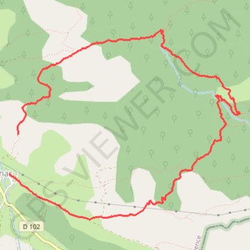
Soleilhas.gpx
- Distance: 5.5 mi
- Elevation gain: 1,296 ft
- Maximum elevation: 4,455 ft
- Elevation loss: 1,516 ft
- Minimum elevation: 3,537 ft
- Moving time: 2 h 53 m
- Moving speed: 1.9 mph
- Maximum speed: 6.0 mph
- Total time: 3 h 42 m
- Global speed: 1.5 mph
Interactive trail map
Trail profile
- Distance: 5.5 mi
- Elevation gain: 1,296 ft
- Maximum elevation: 4,455 ft
- Elevation loss: 1,516 ft
- Minimum elevation: 3,537 ft
- Moving time: 2 h 53 m
- Moving speed: 1.9 mph
- Maximum speed: 6.0 mph
- Total time: 3 h 42 m
- Global speed: 1.5 mph
About this trail
Name: Soleilhas.gpx trail, distance, elevation, map, profile, GPS track
Coordinates: 43.85281 6.65135 43.87114 6.68237
Other hiking, mountain biking, running and outdoor activity trails
Click on a trail to view its statistics, map and profile.
1 LUCENA - MONTPELLIER
Distance: 1,842.0 mi • Elevation gain: 96,785 ft • Maximum elevation: 3,438 ft
PT23DS2 Lörrach → Cadaqués
Germany > Baden-Württemberg > Landkreis Lörrach > Lörrach (Kernstadt)
Distance: 652.9 mi • Elevation gain: 43,077 ft • Maximum elevation: 4,938 ft