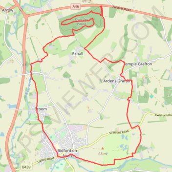
Bidford - Oversley Wood trailrun
- Distance: 12.3 mi
- Elevation gain: 781 ft
- Maximum elevation: 377 ft
- Elevation loss: 781 ft
- Minimum elevation: 102 ft
- Moving time: 1 h 57 m
- Moving speed: 6.3 mph
- Maximum speed: 9.9 mph
- Total time: 1 h 57 m
- Global speed: 6.3 mph
Interactive trail map
Trail profile
- Distance: 12.3 mi
- Elevation gain: 781 ft
- Maximum elevation: 377 ft
- Elevation loss: 781 ft
- Minimum elevation: 102 ft
- Moving time: 1 h 57 m
- Moving speed: 6.3 mph
- Maximum speed: 9.9 mph
- Total time: 1 h 57 m
- Global speed: 6.3 mph
About this trail
Name: Bidford - Oversley Wood trailrun trail, distance, elevation, map, profile, GPS track
Coordinates: 52.16197 -1.87314 52.20846 -1.82063
Other hiking, mountain biking, running and outdoor activity trails
Click on a trail to view its statistics, map and profile.
Alcester trail run
United Kingdom > England > Warwickshire > Stratford-on-Avon > Alcester > Arrow > Oversley Green
Morning Run
Distance: 13.9 mi • Elevation gain: 909 ft • Maximum elevation: 407 ft