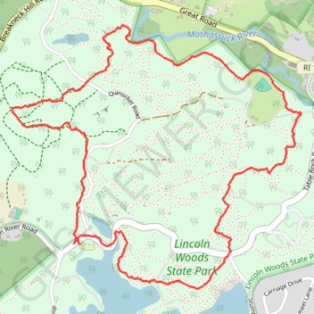
Lincoln Woods Loop Trail in Lincoln Woods State Park
The Lincoln Woods Loop Trail offers an inviting and scenic walk through a mix of dense woodlands and serene lakeside views, ideal for a leisurely outing in nature. Hikers can enjoy the calming presence of Olney Pond, glimpses of small wildlife, and the peaceful forest canopy that provides welcome shade along the path. With its gentle terrain and tranquil atmosphere, this trail offers a refreshing escape close to the city, suitable for hikers of all skill levels. #Hiking #Loop #Forest #Lake #Nature
- Distance: 3.3 mi
- Elevation gain: 272 ft
- Maximum elevation: 292 ft
- Elevation loss: 272 ft
- Minimum elevation: 75 ft
- Moving time: 1 h 8 m
- Moving speed: 2.9 mph
- Maximum speed: 9.3 mph
- Total time: 1 h 11 m
- Global speed: 2.8 mph
Interactive trail map
Trail profile
- Distance: 3.3 mi
- Elevation gain: 272 ft
- Maximum elevation: 292 ft
- Elevation loss: 272 ft
- Minimum elevation: 75 ft
- Moving time: 1 h 8 m
- Moving speed: 2.9 mph
- Maximum speed: 9.3 mph
- Total time: 1 h 11 m
- Global speed: 2.8 mph
About this trail
Name: Lincoln Woods Loop Trail in Lincoln Woods State Park trail, distance, elevation, map, profile, GPS track
Coordinates: 41.89463 -71.43981 41.90574 -71.42339
Topography: Providence County topographic map, elevation, terrain
Other hiking, mountain biking, running and outdoor activity trails
Click on a trail to view its statistics, map and profile.
Cambridge - Providence Express
United States > Massachusetts > Middlesex County > Cambridge
Alewife -> Providence
Distance: 63.2 mi • Elevation gain: 3,153 ft • Maximum elevation: 351 ft
Dedham-Providence-Dedham
United States > Massachusetts > Norfolk County > Dedham
Distance: 126.0 mi • Elevation gain: 5,942 ft • Maximum elevation: 548 ft