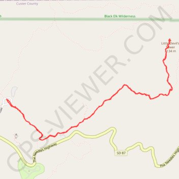
Little Devil's Tower Trail in Custer State Park
The Little Devil's Tower Trail offers an exhilarating experience that’s well worth the effort. The hike is mostly a gentle ascent through stunning rock formations, culminating in a rewarding scramble to the top where breathtaking views of the Black Hills and the Cathedral Spires await. Although the final stretch requires some climbing, taking your time makes it accessible, and the sense of accomplishment at the summit is simply unbeatable. #Hiking #Mountain #Forest #Nature #Rock
- Distance: 4.0 mi
- Elevation gain: 988 ft
- Maximum elevation: 6,900 ft
- Elevation loss: 981 ft
- Minimum elevation: 6,184 ft
- Moving time: 2 h 38 s
- Moving speed: 2.0 mph
- Maximum speed: 4.0 mph
- Total time: 2 h 37 m
- Global speed: 1.5 mph
Interactive trail map
Trail profile
- Distance: 4.0 mi
- Elevation gain: 988 ft
- Maximum elevation: 6,900 ft
- Elevation loss: 981 ft
- Minimum elevation: 6,184 ft
- Moving time: 2 h 38 s
- Moving speed: 2.0 mph
- Maximum speed: 4.0 mph
- Total time: 2 h 37 m
- Global speed: 1.5 mph
About this trail
Name: Little Devil's Tower Trail in Custer State Park trail, distance, elevation, map, profile, GPS track
Coordinates: 43.84261 -103.55981 43.85223 -103.53803
Topography: Custer County topographic map, elevation, terrain
Other hiking, mountain biking, running and outdoor activity trails
Click on a trail to view its statistics, map and profile.
Black Elk Peak Loop via Little Devil's Tower Trail and Black Elk Peak Trail in Black Hills National Forest
United States > South Dakota > Custer County > Sylvan Lake Resort
The Black Elk Peak Loop provides an unforgettable hiking experience through the stunning Black Hills. As you ascend, you’ll enjoy diverse landscapes, including expansive forests, towering rock formations, and sweeping views from the summit of Black Elk Peak, the highest point in South Dakota, where visitors…
Distance: 7.4 mi • Elevation gain: 1,447 ft • Maximum elevation: 7,169 ft
Black Elk Peak Trail in Black Hills National Forest
United States > South Dakota > Custer County > Sylvan Lake Resort
The Black Elk Peak Trail offers a fantastic hiking experience that combines natural beauty and cultural significance. Starting from Sylvan Lake, the trail winds through dense pine forests, rugged granite formations, and features the famous Cathedral Spires. The climb is moderately challenging, with rewarding…
Distance: 6.8 mi • Elevation gain: 1,503 ft • Maximum elevation: 7,169 ft
Black Elk Peak Loop via Little Devil's Tower in Black Hills National Forest
United States > South Dakota > Custer County > Sylvan Lake Resort
This loop trail to Black Elk Peak and Little Devil's Tower is an absolute gem for hikers exploring South Dakota's Black Hills. This well-maintained loop starts at Sylvan Lake and offers breathtaking panoramas, rugged rock formations, and a chance to experience two iconic summits in one trek. While challenging,…
Distance: 8.0 mi • Elevation gain: 1,870 ft • Maximum elevation: 7,169 ft