Thank you for supporting this site ❤️
Make a donation
Make a donation
Gear up for your next adventure:
As an Amazon Associate, this site earns from qualifying purchases at no extra cost to you.
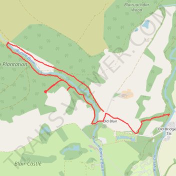
Walk near Old Blair
- Distance: 3.9 mi
- Elevation gain: 571 ft
- Maximum elevation: 912 ft
- Elevation loss: 535 ft
- Minimum elevation: 558 ft
- Moving time: 1 h 36 m
- Moving speed: 2.4 mph
- Maximum speed: 5.4 mph
- Total time: 1 h 50 m
- Global speed: 2.1 mph
Interactive trail map
Thank you for supporting this site ❤️
Make a donation
Make a donation
Gear up for your next adventure:
As an Amazon Associate, this site earns from qualifying purchases at no extra cost to you.
Trail profile
- Distance: 3.9 mi
- Elevation gain: 571 ft
- Maximum elevation: 912 ft
- Elevation loss: 535 ft
- Minimum elevation: 558 ft
- Moving time: 1 h 36 m
- Moving speed: 2.4 mph
- Maximum speed: 5.4 mph
- Total time: 1 h 50 m
- Global speed: 2.1 mph
Thank you for supporting this site ❤️
Make a donation
Make a donation
Gear up for your next adventure:
As an Amazon Associate, this site earns from qualifying purchases at no extra cost to you.
About this trail
Name: Walk near Old Blair trail, distance, elevation, map, profile, GPS track
Coordinates: 56.77526 -3.87819 56.78712 -3.83946
Thank you for supporting this site ❤️
Make a donation
Make a donation
Gear up for your next adventure:
As an Amazon Associate, this site earns from qualifying purchases at no extra cost to you.