Thank you for supporting this site ❤️
Make a donation
Make a donation
Gear up for your next adventure:
As an Amazon Associate, this site earns from qualifying purchases at no extra cost to you.
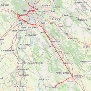
Track_AECW_821_2023_11_27_2023_11_27_1701185001391
- Distance: 102.2 mi
- Elevation gain: 2,146 ft
- Maximum elevation: 801 ft
- Elevation loss: 2,165 ft
- Minimum elevation: 331 ft
Interactive trail map
Thank you for supporting this site ❤️
Make a donation
Make a donation
Gear up for your next adventure:
As an Amazon Associate, this site earns from qualifying purchases at no extra cost to you.
Trail profile
- Distance: 102.2 mi
- Elevation gain: 2,146 ft
- Maximum elevation: 801 ft
- Elevation loss: 2,165 ft
- Minimum elevation: 331 ft
Thank you for supporting this site ❤️
Make a donation
Make a donation
Gear up for your next adventure:
As an Amazon Associate, this site earns from qualifying purchases at no extra cost to you.
About this trail
Name: Track_AECW_821_2023_11_27_2023_11_27_1701185001391 trail, distance, elevation, map, profile, GPS track
Coordinates: 46.80155 18.88404 47.56076 19.62722
Thank you for supporting this site ❤️
Make a donation
Make a donation
Gear up for your next adventure:
As an Amazon Associate, this site earns from qualifying purchases at no extra cost to you.
Other hiking, mountain biking, running and outdoor activity trails
Click on a trail to view its statistics, map and profile.
Privdat1 délután
Distance: 10.8 mi • Elevation gain: 249 ft • Maximum elevation: 397 ft