Hampton Hills MTB lower sections
- Distance: 5.6 mi
- Elevation gain: 390 ft
- Maximum elevation: 942 ft
- Elevation loss: 390 ft
- Minimum elevation: 761 ft
- Moving time: 1 h 38 s
- Moving speed: 5.5 mph
- Maximum speed: 7.4 mph
- Total time: 1 h 2 m
- Global speed: 5.4 mph
Interactive trail map
Trail profile
- Distance: 5.6 mi
- Elevation gain: 390 ft
- Maximum elevation: 942 ft
- Elevation loss: 390 ft
- Minimum elevation: 761 ft
- Moving time: 1 h 38 s
- Moving speed: 5.5 mph
- Maximum speed: 7.4 mph
- Total time: 1 h 2 m
- Global speed: 5.4 mph
About this trail
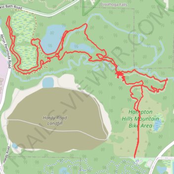
Name: Hampton Hills MTB lower sections trail, distance, elevation, map, profile, GPS track
Start: Straightaway, Akron, Summit County, Ohio, 44313, United States (41.15128 -81.55107)
End: Straightaway, Akron, Summit County, Ohio, 44313, United States (41.15133 -81.55108)
Coordinates: 41.15128 -81.56534 41.16316 -81.54738
Topography: Akron topographic map, elevation, terrain
Other hiking, mountain biking, running and outdoor activity trails
Click on a trail to view its statistics, map and profile.
Hampton Hills MTB D Loop
United States > Ohio > Summit County > Akron
Akron Mountain Biking
Distance: 6.5 mi • Elevation gain: 371 ft • Maximum elevation: 942 ft