Make a donation
Gear up for your next adventure:
As an Amazon Associate, this site earns from qualifying purchases at no extra cost to you.
Tahoe Donner Adventure Center
Euer Valley
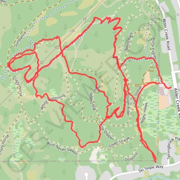
- Distance: 6.6 mi
- Elevation gain: 791 ft
- Maximum elevation: 7,041 ft
- Elevation loss: 787 ft
- Minimum elevation: 6,634 ft
Interactive trail map
Make a donation
Gear up for your next adventure:
As an Amazon Associate, this site earns from qualifying purchases at no extra cost to you.
Trail profile
- Distance: 6.6 mi
- Elevation gain: 791 ft
- Maximum elevation: 7,041 ft
- Elevation loss: 787 ft
- Minimum elevation: 6,634 ft
Make a donation
Gear up for your next adventure:
As an Amazon Associate, this site earns from qualifying purchases at no extra cost to you.
About this trail
Name: Tahoe Donner Adventure Center trail, distance, elevation, map, profile, GPS track
Start: Alder Creek Trail, Truckee, Nevada County, California, 95161, United States (39.36415 -120.25377)
End: Alder Creek Trail, Truckee, Nevada County, California, 95161, United States (39.36419 -120.25418)
Coordinates: 39.35886 -120.26743 39.36861 -120.25300
Topography: Nevada County topographic map, elevation, terrain
Make a donation
Gear up for your next adventure:
As an Amazon Associate, this site earns from qualifying purchases at no extra cost to you.