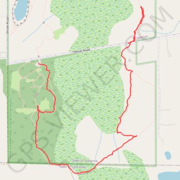
Clarence NY: Tillman Rd Wildlife Management Area southeast trail
Park, trail
- Distance: 1.6 mi
- Elevation gain: 39 ft
- Maximum elevation: 768 ft
- Elevation loss: 36 ft
- Minimum elevation: 741 ft
- Moving time: 45 m 22 s
- Moving speed: 2.1 mph
- Maximum speed: 4.4 mph
- Total time: 59 m 51 s
- Global speed: 1.6 mph
Interactive trail map
Trail profile
- Distance: 1.6 mi
- Elevation gain: 39 ft
- Maximum elevation: 768 ft
- Elevation loss: 36 ft
- Minimum elevation: 741 ft
- Moving time: 45 m 22 s
- Moving speed: 2.1 mph
- Maximum speed: 4.4 mph
- Total time: 59 m 51 s
- Global speed: 1.6 mph
About this trail
Name: Clarence NY: Tillman Rd Wildlife Management Area southeast trail trail, distance, elevation, map, profile, GPS track
Coordinates: 42.95460 -78.61074 42.96274 -78.60349
Topography: Erie County topographic map, elevation, terrain
Other hiking, mountain biking, running and outdoor activity trails
Click on a trail to view its statistics, map and profile.
Tillman Park one of the loops South of Tillman Road
United States > New York > Erie County > Clarence
Distance: 1.2 mi • Elevation gain: 33 ft • Maximum elevation: 768 ft