Make a donation
Gear up for your next adventure:
As an Amazon Associate, this site earns from qualifying purchases at no extra cost to you.
Munro, hillwalk, Choinnich, Mor, Aonach, Beag
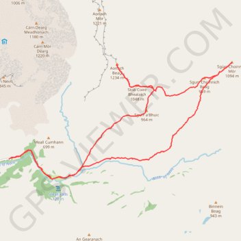
- Distance: 13.5 mi
- Elevation gain: 5,696 ft
- Maximum elevation: 4,045 ft
- Elevation loss: 5,696 ft
- Minimum elevation: 453 ft
- Moving time: 7 h 34 m
- Moving speed: 1.8 mph
- Maximum speed: 4.4 mph
- Total time: 8 h 35 m
- Global speed: 1.6 mph
Interactive trail map
Make a donation
Gear up for your next adventure:
As an Amazon Associate, this site earns from qualifying purchases at no extra cost to you.
Trail profile
- Distance: 13.5 mi
- Elevation gain: 5,696 ft
- Maximum elevation: 4,045 ft
- Elevation loss: 5,696 ft
- Minimum elevation: 453 ft
- Moving time: 7 h 34 m
- Moving speed: 1.8 mph
- Maximum speed: 4.4 mph
- Total time: 8 h 35 m
- Global speed: 1.6 mph
Make a donation
Gear up for your next adventure:
As an Amazon Associate, this site earns from qualifying purchases at no extra cost to you.
About this trail
Name: Munro, hillwalk, Choinnich, Mor, Aonach, Beag trail, distance, elevation, map, profile, GPS track
Start: Glen Nevis Road, Highland, Scotland, United Kingdom (56.77727 -5.00120)
End: Glen Nevis Road, Highland, Scotland, United Kingdom (56.77728 -5.00119)
Coordinates: 56.77253 -5.00120 56.80043 -4.90398
Make a donation
Gear up for your next adventure:
As an Amazon Associate, this site earns from qualifying purchases at no extra cost to you.
Other hiking, mountain biking, running and outdoor activity trails
Click on a trail to view its statistics, map and profile.
Munro Hillwalk - Ring of Steall
United Kingdom > Scotland > Highland > Achriabhach
Starting at Glen Nevis Lower Falls, this anticlockwise Ring of Steall climb rises from the Water of Nevis onto the pale quartzite slopes of Sgùrr a’ Mhàim, where the view opens across Glen Nevis, Ben Nevis and the Mamores. The route then follows the high ridge over The Devil’s Ridge and Sgòr an Iubhair…
Distance: 11.6 mi • Elevation gain: 5,400 ft • Maximum elevation: 3,573 ft