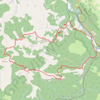
MAGLEŠ Lastra - Zabava - Kušakovići - vrh Pali - Gornje Lesk...
- Distance: 9.3 mi
- Elevation gain: 2,549 ft
- Maximum elevation: 3,320 ft
- Elevation loss: 2,549 ft
- Minimum elevation: 1,201 ft
Interactive trail map
Trail profile
- Distance: 9.3 mi
- Elevation gain: 2,549 ft
- Maximum elevation: 3,320 ft
- Elevation loss: 2,549 ft
- Minimum elevation: 1,201 ft
About this trail
Name: MAGLEŠ Lastra - Zabava - Kušakovići - vrh Pali - Gornje Lesk... trail, distance, elevation, map, profile, GPS track
Coordinates: 44.14287 19.83117 44.16687 19.88451
Other hiking, mountain biking, running and outdoor activity trails
Click on a trail to view its statistics, map and profile.
2022_Yu
Slovenia > Ajdovščina > Žapuže
Distance: 1,526.9 mi • Elevation gain: 105,144 ft • Maximum elevation: 6,398 ft