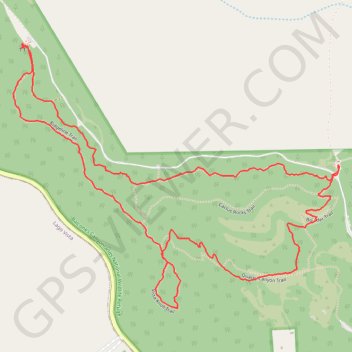
Vista Knoll and Ridgeline Loop Via Cactus Rocks Trail
Trail at Balcones Canyonlands National Wildlife Refuge
- Distance: 3.2 mi
- Elevation gain: 417 ft
- Maximum elevation: 1,273 ft
- Elevation loss: 417 ft
- Minimum elevation: 1,001 ft
- Moving time: 1 h 13 m
- Moving speed: 2.6 mph
- Maximum speed: 4.3 mph
- Total time: 1 h 27 m
- Global speed: 2.2 mph
Interactive trail map
Trail profile
- Distance: 3.2 mi
- Elevation gain: 417 ft
- Maximum elevation: 1,273 ft
- Elevation loss: 417 ft
- Minimum elevation: 1,001 ft
- Moving time: 1 h 13 m
- Moving speed: 2.6 mph
- Maximum speed: 4.3 mph
- Total time: 1 h 27 m
- Global speed: 2.2 mph
About this trail
Name: Vista Knoll and Ridgeline Loop Via Cactus Rocks Trail trail, distance, elevation, map, profile, GPS track
Start: Cactus Rocks Trail, Travis County, Texas, United States (30.50599 -97.97958)
End: Cactus Rocks Trail, Travis County, Texas, United States (30.50598 -97.97959)
Coordinates: 30.50098 -97.99275 30.51022 -97.97956
Topography: Travis County topographic map, elevation, terrain