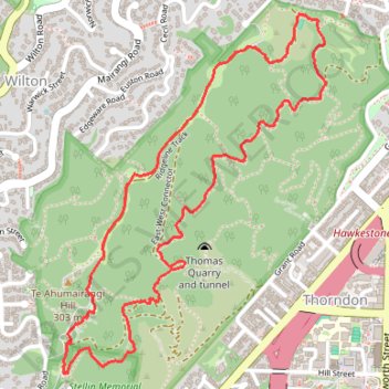
Te Ahumairangi Reserve Loop Walk
- Distance: 2.8 mi
- Elevation gain: 837 ft
- Maximum elevation: 932 ft
- Elevation loss: 840 ft
- Minimum elevation: 456 ft
- Moving time: 1 h 9 m
- Moving speed: 2.4 mph
- Maximum speed: 4.9 mph
- Total time: 1 h 45 m
- Global speed: 1.6 mph
Interactive trail map
Trail profile
- Distance: 2.8 mi
- Elevation gain: 837 ft
- Maximum elevation: 932 ft
- Elevation loss: 840 ft
- Minimum elevation: 456 ft
- Moving time: 1 h 9 m
- Moving speed: 2.4 mph
- Maximum speed: 4.9 mph
- Total time: 1 h 45 m
- Global speed: 1.6 mph
About this trail
Name: Te Ahumairangi Reserve Loop Walk trail, distance, elevation, map, profile, GPS track
Coordinates: -41.27698 174.76400 -41.26540 174.77524
Other hiking, mountain biking, running and outdoor activity trails
Click on a trail to view its statistics, map and profile.
Welington
New Zealand > Wellington > Wellington City > Wellington
Distance: 46.3 mi • Elevation gain: 2,907 ft • Maximum elevation: 732 ft