Thank you for supporting this site ❤️
Make a donation
Make a donation
Gear up for your next adventure:
As an Amazon Associate, this site earns from qualifying purchases at no extra cost to you.
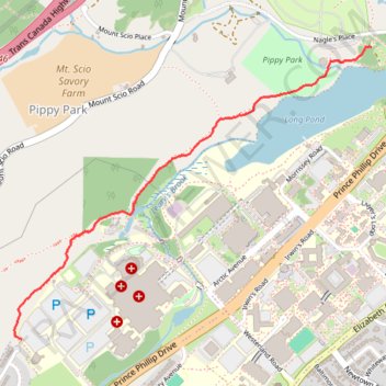
Long Pond Trail
- Distance: 1.2 mi
- Elevation gain: 154 ft
- Maximum elevation: 259 ft
- Elevation loss: 180 ft
- Minimum elevation: 167 ft
- Moving time: 23 m 43 s
- Moving speed: 3.1 mph
- Maximum speed: 4.7 mph
- Total time: 23 m 43 s
- Global speed: 3.1 mph
Interactive trail map
Thank you for supporting this site ❤️
Make a donation
Make a donation
Gear up for your next adventure:
As an Amazon Associate, this site earns from qualifying purchases at no extra cost to you.
Trail profile
- Distance: 1.2 mi
- Elevation gain: 154 ft
- Maximum elevation: 259 ft
- Elevation loss: 180 ft
- Minimum elevation: 167 ft
- Moving time: 23 m 43 s
- Moving speed: 3.1 mph
- Maximum speed: 4.7 mph
- Total time: 23 m 43 s
- Global speed: 3.1 mph
Thank you for supporting this site ❤️
Make a donation
Make a donation
Gear up for your next adventure:
As an Amazon Associate, this site earns from qualifying purchases at no extra cost to you.
About this trail
Name: Long Pond Trail trail, distance, elevation, map, profile, GPS track
Coordinates: 47.57032 -52.74824 47.58033 -52.73014
Thank you for supporting this site ❤️
Make a donation
Make a donation
Gear up for your next adventure:
As an Amazon Associate, this site earns from qualifying purchases at no extra cost to you.
Other hiking, mountain biking, running and outdoor activity trails
Click on a trail to view its statistics, map and profile.
Whitbourne - St. John's
Canada > Newfoundland and Labrador > Whitbourne
#Bike #Whitbourne #StJohns #Newfoundland #Atlantic
Distance: 64.2 mi • Elevation gain: 4,035 ft • Maximum elevation: 768 ft