Thank you for supporting this site ❤️
Make a donation
Make a donation
Gear up for your next adventure:
As an Amazon Associate, this site earns from qualifying purchases at no extra cost to you.
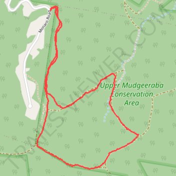
Upper Mudgeeraba Conservation Area
- Distance: 3.0 mi
- Elevation gain: 863 ft
- Maximum elevation: 915 ft
- Elevation loss: 860 ft
- Minimum elevation: 322 ft
- Moving time: 1 h 46 m
- Moving speed: 1.7 mph
- Maximum speed: 3.4 mph
- Total time: 1 h 57 m
- Global speed: 1.5 mph
Interactive trail map
Thank you for supporting this site ❤️
Make a donation
Make a donation
Gear up for your next adventure:
As an Amazon Associate, this site earns from qualifying purchases at no extra cost to you.
Trail profile
- Distance: 3.0 mi
- Elevation gain: 863 ft
- Maximum elevation: 915 ft
- Elevation loss: 860 ft
- Minimum elevation: 322 ft
- Moving time: 1 h 46 m
- Moving speed: 1.7 mph
- Maximum speed: 3.4 mph
- Total time: 1 h 57 m
- Global speed: 1.5 mph
Thank you for supporting this site ❤️
Make a donation
Make a donation
Gear up for your next adventure:
As an Amazon Associate, this site earns from qualifying purchases at no extra cost to you.
About this trail
Name: Upper Mudgeeraba Conservation Area trail, distance, elevation, map, profile, GPS track
Start: Monaro Road, Mudgeeraba, Gold Coast City, Queensland, Australia (-28.10628 153.33718)
End: Monaro Road, Mudgeeraba, Gold Coast City, Queensland, Australia (-28.10638 153.33722)
Coordinates: -28.11863 153.33602 -28.10608 153.34487
Thank you for supporting this site ❤️
Make a donation
Make a donation
Gear up for your next adventure:
As an Amazon Associate, this site earns from qualifying purchases at no extra cost to you.