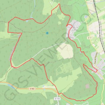
Mont-le-Vignoble
- Distance: 9.2 mi
- Elevation gain: 1,250 ft
- Maximum elevation: 1,378 ft
- Elevation loss: 1,250 ft
- Minimum elevation: 899 ft
Interactive trail map
Trail profile
- Distance: 9.2 mi
- Elevation gain: 1,250 ft
- Maximum elevation: 1,378 ft
- Elevation loss: 1,250 ft
- Minimum elevation: 899 ft
About this trail
Name: Mont-le-Vignoble trail, distance, elevation, map, profile, GPS track
Coordinates: 48.60206 5.79587 48.63455 5.84130
Other hiking, mountain biking, running and outdoor activity trails
Click on a trail to view its statistics, map and profile.
Riethoven naar Oostenrijk
Netherlands > North Brabant > Riethoven > Eind
Distance: 573.0 mi • Elevation gain: 44,715 ft • Maximum elevation: 6,224 ft
Eurovelo 15 - Strasbourg Rotterdam
France > Grand Est > Bas-Rhin > Strasbourg
Distance: 554.1 mi • Elevation gain: 6,903 ft • Maximum elevation: 479 ft