Thank you for supporting this site ❤️
Make a donation
Make a donation
Gear up for your next adventure:
As an Amazon Associate, this site earns from qualifying purchases at no extra cost to you.
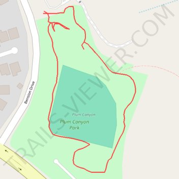
Plum Canyon Park Loop Walk
- Distance: 0.5 mi
- Elevation gain: 89 ft
- Maximum elevation: 1,775 ft
- Elevation loss: 89 ft
- Minimum elevation: 1,709 ft
- Moving time: 14 m 8 s
- Moving speed: 2.1 mph
- Maximum speed: 4.2 mph
- Total time: 15 m 24 s
- Global speed: 2.0 mph
Interactive trail map
Thank you for supporting this site ❤️
Make a donation
Make a donation
Gear up for your next adventure:
As an Amazon Associate, this site earns from qualifying purchases at no extra cost to you.
Trail profile
- Distance: 0.5 mi
- Elevation gain: 89 ft
- Maximum elevation: 1,775 ft
- Elevation loss: 89 ft
- Minimum elevation: 1,709 ft
- Moving time: 14 m 8 s
- Moving speed: 2.1 mph
- Maximum speed: 4.2 mph
- Total time: 15 m 24 s
- Global speed: 2.0 mph
Thank you for supporting this site ❤️
Make a donation
Make a donation
Gear up for your next adventure:
As an Amazon Associate, this site earns from qualifying purchases at no extra cost to you.
About this trail
Name: Plum Canyon Park Loop Walk trail, distance, elevation, map, profile, GPS track
Coordinates: 34.44356 -118.46597 34.44577 -118.46448
Topography: Santa Clarita topographic map, elevation, terrain
Thank you for supporting this site ❤️
Make a donation
Make a donation
Gear up for your next adventure:
As an Amazon Associate, this site earns from qualifying purchases at no extra cost to you.