Thank you for supporting this site ❤️
Make a donation
Make a donation
Gear up for your next adventure:
As an Amazon Associate, this site earns from qualifying purchases at no extra cost to you.
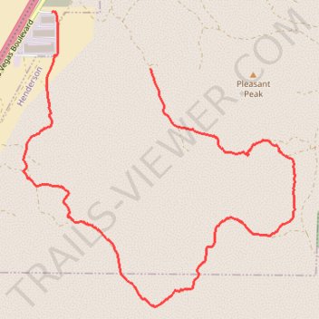
Sloan South East Loop Hike
- Distance: 5.1 mi
- Elevation gain: 564 ft
- Maximum elevation: 3,225 ft
- Elevation loss: 604 ft
- Minimum elevation: 2,795 ft
- Moving time: 1 h 36 m
- Moving speed: 3.2 mph
- Maximum speed: 4.8 mph
- Total time: 1 h 39 m
- Global speed: 3.1 mph
Interactive trail map
Thank you for supporting this site ❤️
Make a donation
Make a donation
Gear up for your next adventure:
As an Amazon Associate, this site earns from qualifying purchases at no extra cost to you.
Trail profile
- Distance: 5.1 mi
- Elevation gain: 564 ft
- Maximum elevation: 3,225 ft
- Elevation loss: 604 ft
- Minimum elevation: 2,795 ft
- Moving time: 1 h 36 m
- Moving speed: 3.2 mph
- Maximum speed: 4.8 mph
- Total time: 1 h 39 m
- Global speed: 3.1 mph
Thank you for supporting this site ❤️
Make a donation
Make a donation
Gear up for your next adventure:
As an Amazon Associate, this site earns from qualifying purchases at no extra cost to you.
About this trail
Name: Sloan South East Loop Hike trail, distance, elevation, map, profile, GPS track
Start: Henderson, Clark County, Nevada, United States (35.91404 -115.18888)
End: Clark County, Nevada, 89054, United States (35.91867 -115.19889)
Coordinates: 35.89443 -115.20180 35.91871 -115.17417
Topography: Henderson topographic map, elevation, terrain
Thank you for supporting this site ❤️
Make a donation
Make a donation
Gear up for your next adventure:
As an Amazon Associate, this site earns from qualifying purchases at no extra cost to you.