Nyaania Creek Loop Walk Trail
- Distance: 1.5 mi
- Elevation gain: 348 ft
- Maximum elevation: 440 ft
- Elevation loss: 348 ft
- Minimum elevation: 89 ft
- Moving time: 1 h 13 m
- Moving speed: 1.2 mph
- Maximum speed: 4.9 mph
- Total time: 1 h 52 m
- Global speed: 0.8 mph
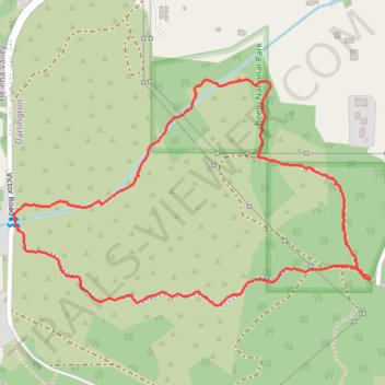
Interactive trail map
Trail profile
- Distance: 1.5 mi
- Elevation gain: 348 ft
- Maximum elevation: 440 ft
- Elevation loss: 348 ft
- Minimum elevation: 89 ft
- Moving time: 1 h 13 m
- Moving speed: 1.2 mph
- Maximum speed: 4.9 mph
- Total time: 1 h 52 m
- Global speed: 0.8 mph
About this trail
Name: Nyaania Creek Loop Walk Trail trail, distance, elevation, map, profile, GPS track
Start: Glen Road, Darlington, Shire of Mundaring, Western Australia, 6070, Australia (-31.93265 116.07553)
End: Glen Road, Darlington, Shire of Mundaring, Western Australia, 6070, Australia (-31.93260 116.07550)
Coordinates: -31.93319 116.06703 -31.92861 116.07553
Other hiking, mountain biking, running and outdoor activity trails
Click on a trail to view its statistics, map and profile.
Perth - WAMC King of the Mountain
Distance: 9.9 mi • Elevation gain: 1,325 ft • Maximum elevation: 810 ft
2021 Toodyay return via Kep
Distance: 142.9 mi • Elevation gain: 6,099 ft • Maximum elevation: 1,171 ft